Djety-Oguz Route And Karakol Peak
About this tour
Jeti-Oguz and the Valley of Flowers! An ideal route for those wishing to spend their weekend active and see as much as possible. Acquaintance with the mountains of Kyrgyzstan should start from this route, as it covers almost all the main places of Issyk-Kul. We are waiting for a few pass over 3800 meters, mountain lakes and panoramas of eternal ice! And also we will come to the foot of the majestic Karakol peak from where the Karakol river begins, which gives life to many villages and cities! Hot springs of the Altyn-Arashan valley, picturesque gorges of Karakol and wild animals that are often found on the way are just a small part of a big trip! But that's not all, we will also drive around Lake Issy-Kul and visit many sights of these places, so that you would like to come here again and see even more!
Please Note: It is necessary to have warm clothes, spare clothes, good boots and spare sport shoes, a rain jacket, sun glasses, sunblock (cream). If you have a specific disease, you should have your own first aid kit with the necessary medicines.
Attention:
Tourists must have no medical contraindications for the trekking and hiking.
In case of bad weather, a tour guide has a right to change the route in a safety purpose.
Day-by-day itinerary
Day 1: Manas International Airport, Kyrgyzstan to Bishkek, Kyrgyzstan
Upon arrival to the international airport Manas you will be met by a guide. Short drive to Bishkek and accommodation in a hotel. Meals - /-/D Detailed information: Minimum altitude: 635 m. Highest altitude: 800 m. Distance by car: 40 km.
Day 2: Bishkek, Kyrgyzstan
After breakfast, briefing by guide. followed by city tour. We visit Manas Monument, the main national hero of the Kyrgyz people. Then excursion to the State History Museum and walking tour around main Ala Too Square to watch ceremony of changing of the Guard of Honor, Kurmanzhan Datka Monument, main governmental buildings, and finish at the Old Square with Government House. On the way, stop at a cafe (lunch is paid for by yourself). Transfer to the Victory Square to finish the city tour by short excursion there. Dinner in a local restaurant. Overnight in a hotel. Meals B/-/D Detailed information: Minimum altitude: 635 m. Highest altitude: 800 m. Total distance by car: 50 km.
Day 3: Bishkek, Kyrgyzstan to Karakol, Kyrgyzstan
After breakfast we drive to Issyk Kul Lake that is considered to be the pearl of Tien Shan and one of the most beautiful lakes in the country. Our way goes via ruins of Burana Tower (old minaret) near Tokmok city. On the way, stop at a cafe (lunch is paid for by yourself). In the late afternoon three hours’ drive to Issyk Kul Lake, the second largest alpine lake in the world after Lake Titicaca in South America. En route we also visit so called Stone garden or Cholpon Ata Petroglyphs site, the temple in the open air of Scythians and Hung suns civilizations dated back 9-8 centuries BC till 3-4 centuries AD. The area of those stone drawing lies at the foot of Kungei Alatau Ridge with a beautiful view of the whole lake. Continue driving to Karakol town. Upon arrival accommodation in a guest house. Dinner in a local café. Overnight in a guest house. Meals B/-/D Detailed information: Minimum altitude: 635 m. Highest altitude: 1700 m. Distance: 410 km.
Day 4: Karakol, Kyrgyzstan to Jety - Oguz, Kyrgyzstan
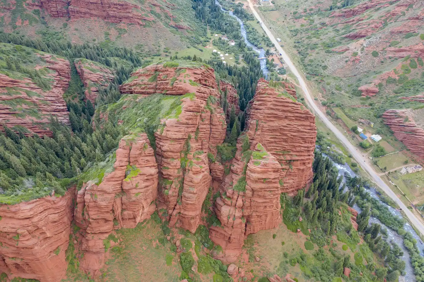
Morning short sightseeing tour in the town – Dungan Mosque, Russian Orthodox Cathedral, Prjevalskii Memorial Complex. On the way, stop at a cafe (lunch is paid for by yourself). Transfer to Djety Oguz gorge located in the Northern slopes of Terskei Ala Too some 35km west from Karakol town. The length of the valley is 40 km. There is a chance to see the well-known redsand rock formations – The Broken Heart and Seven Bulls. The slopes in the gorge are covered with the world-famous Tien Shan blue spruce for about 25km along the fast mountain river. The road goes along the river (five log bridges to cross). This is the narrowest part of the way. Later it opens into so called Flower Meadow (Kok Jaiyk). The upper part of Djety Oguz valley is blocked by a long Djety Oguz wall with a fabulous Oguz Bashi peak (5165m) in the central part of it. Dinner and overnight in Djety Oguz tent camp at 2600m. Meals B/-/D Detailed information: Minimum altitude: 1688 m. Average altitude: 1853 m. Highest altitude: 2302 m. Distance: 80 km. Maximum gradient: 15% Average gradient: 2% Travel time by car: 1 h. Travel time: 2 h.
Day 5: Jety - Oguz, Kyrgyzstan
The path along the river bank in a very narrow wooded gorge Bay Tor leads us to the alpine meadows. Here, on a flower carpet, in the mountains the air is sweet and clear, the views are amazing, one forgets all his troubles and gets closer to the nature. Picnic. After rest continue the trek to the tent camp at the foot of Telety pass. It is not a difficult trek, about 6-7km along West Telety river. Dinner and overnight in Telety tent camp at 3050m. Meals B/L/D Detailed information: Minimum altitude: 2276 m. Average altitude: 2684 m. Highest altitude: 3050 m. Distance: 12 km. Maximum gradient: 8% Average gradient: 2% Travel time: 6 h.
Day 6: Ala-Kul, Kyrgyzstan
Going up the pass is not very difficult, mainly the route goes along a narrow path with a slight ascend. There are only two rather steep slopes, which require some efforts. From the top of the pass at 3800m asl we enjoy the views of the surroundings. Descent is rather simple, along a wide slope covered with talus, across alpine meadows with various herbs and flowers, along East Telety river. Later we hike through the wood along a trail covered with roots. Dinner and overnight in Karakol tent camp at 2500m. Meals B/L/D Detailed information: Minimum altitude: 2581 m. Average altitude: 3262 m. Highest altitude: 3780 m. Distance: 10 km. Maximum gradient: 36% Average gradient: 21% Travel time: 6 h.
Day 7: Ala-Kul, Kyrgyzstan
Radial hike up along Karakol river to the foot of Karakol peak. We have a chance to see Tien Shan blue spruce forest, underwood (dog rose, honeysuckle, black barberries, mountain ash, black current, etc. There are mushrooms in the forest. Starting from May there are flowers blooming on the meadows – snowdrops, tulips, primerose, white anemone, alpine Aster, edelweiss (really big ones), etc. We reach the point with a view at the highest peak of Terskei Ala Too – Karakol peak. Diner and overnight in Karakol tent camp at 2500m. Meals B/L/D Detailed information: Minimum altitude: 2578 m. Average altitude: 3045 m. Highest altitude: 3536 m. Distance: 24 km. Maximum gradient: 34% Average gradient: 25% Travel time: 8 h.
Day 8: Ala-Kul, Kyrgyzstan
Day 8: Ala-Kol lake Descent along the gorge about 3 km, later we cross the river over a bridge and the trail leads us into a forest. Rather long ascent finishes at a steep slope covered with grass, the trail turns into a serpentine, passes by a river overflow, and arrive to an unusual place which is called “Sirota” mountain hut. It is a log hut. There is a table, benches, fireplace inside. We can find a number of sculptures of animals and idols carved in wood around the hut. It looks like a fairy tale place. It is a nice place to sit down, rest, have a snack. Later the trail goes up higher, leaving the forest behind we hike along the river and reach a beautiful waterfall, flowing down from Ala Kol Lake. Dinner and overnight in Ala Kol tent camp at 3600m. Meals B/L/D Detailed information: Minimum altitude: 2531 m. Average altitude: 2934 m. Highest altitude: 3634 m. Distance: 9 km. Maximum gradient: 40% Average gradient: 19% Travel time: 7 h.
Day 9: Ala-Kul, Kyrgyzstan to Altyn-Arashan, Kyrgyzstan
Moraine Lake of Ala Kol stretches from east to west for 2.8km, its width is 500m, and depth 70m. Ala Kol means Colorful Lake in Kyrgyz language. Depending on the light the water might change its color. It can be emerald green, turquoise with white clouds reflected, light green or dark grey, or even black. During the ascent we enjoy wonderful views of the lake. Arriving closer to the lake we see the main range of Terskei Ala Too with a number of peaks – Aksu, Djigit, Karakol, Oguz Bashi, etc. From the lake edge it will take us another hour and half to the pass. Descent from the pass along a talus slope, and later across a wide valley of Keldike with picturesque landscapes, herds of cattle and flocks of sheep grazing. Later the trail brings us into a forest again and descends into Arashan valley. Upon arrival to the tent camp you may use an opportunity to relax in the hot springs. There are thermal baths (up to +50C) in the valley. Possibility to take thermal baths. Dinner and overnight in Altyn Arashan yurt camp at 2600m. Meals B/L/D Detailed information: Minimum altitude: 2507 m. Average altitude: 3098 m. Highest altitude: 3880 m. Distance: 12 km. Maximum gradient: 42% Average gradient: 14% Travel time: 7 h.
Day 10: Ak-Suu Dendrarium, Kyrgyzstan to Cholpon Ata, Kyrgyzstan
There is a resort Altyn Arashan founded 1963, famous for its hot mineral springs. The resort represents several wooden huts located on a big treeless meadow on the right bank of Arashan river. The Northern slopes of the left river bank are covered with fir trees. It gives an unforgettable picture – dark green trees with snowcapped mountains Aksu wall (5022m) in the background. Transfer to Cholpon Ata city. Possibly to descent over green fields with blooming flowers and crystal mountain springs. The final 5 km of the gorge are very narrow not more than 30 m with high rock walls. At the entrance to the gorge we pass by a village – Ak Suu (the name comes from the hot springs). Here you will take place inside the car. On the way, stop at a cafe (lunch is paid for by yourself). Accommodation in a hotel on the north shore of Issyk Kul Lake. Dinner and overnight in a hotel. Meals B/-/D Detailed information: Minimum altitude: 1880 m. Average altitude: 2186 m. Highest altitude: 2560 m. Distance: 14 km. Distance by car: 150 km. Maximum gradient: 42% Average gradient: 14% Travel time by car: 7 h.
Day 11: Cholpon Ata, Kyrgyzstan to Bishkek, Kyrgyzstan
Morning, after breakfast, transfer to Bishkek city. On the way, stop at a cafe (lunch is paid for by yourself). Upon arrival to the city accommodation in a hotel. Diner in a local restaurant. Meals B/-/D Detailed information: Minimum altitude: 663 m. Average altitude: 1246 m. Highest altitude: 1650 m. Distance by car: 260 km. Maximum gradient: - Average gradient: - Travel time by car: 6 h.
Day 12: Bishkek, Kyrgyzstan to Manas International Airport, Kyrgyzstan
Evening transfer to airport to catch your flight back home. End of program. Meals B/-/- Detailed information: Minimum altitude: 634 m. Average altitude: 688 m. Highest altitude: 757 m. Distance by car: 32 km. Maximum gradient: - Average gradient: - Travel time by car: 1 h.
What's included
What is included: Transfer for all program Hot springs (fee to the pool) Transfer to the starting point of the track and back Meals during track (B-L-D) Taxes and duties Tents Sleeping mat Guide Cook Porter (for equipment) Guide for all program Accommodation for all program Some meals are paid for by yourself. Yurt in arashan valley
Rent of hourses Sleeping bag Food during the transfer (road cafe) Bag pack Porter (for personal luggage 20 kg.) 25 USD per day Folklore and other shows Purchases
What to know
This tour can be customized. Please get in touch with me.
Route & locations
Manas International Airport, Kyrgyzstan to Bishkek, Kyrgyzstan